 Catalogue PIGMA
/Human activities/Fisheries
Type of resources
Available actions
Topics
Keywords
Contact for the resource
Provided by
Years
Formats
Representation types
Update frequencies
status
-
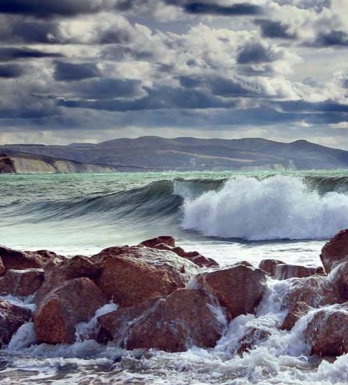
The North East Atlantic Fisheries Commission (NEAFC) is the Regional Fisheries Management Organisation (RFMO) for the North East Atlantic, one of the most abundant fishing areas in the world. It is comprised of Contracting Parties which have signed up to the Convention on Multilateral Cooperation in North East Atlantic Fisheries, which entered into force in November 1982. The area covered by the NEAFC Convention stretches from the southern tip of Greenland, east to the Barents Sea, and south to Portugal. Most of the information on this website is aimed at scientists, control experts, statisticians and managers from the Contracting Parties and other international organisations. The objective of NEAFC is to ensure the long-term conservation and optimum utilisation of the fishery resources in its Convention Area, providing sustainable economic, environmental and social benefits.
-
Explore global fisheries and aquaculture. Understand their status and how impacts are being managed. Learn what improvements are underway, and see what actions seafood stakeholders can take to drive sustainability. FishSource is a publicly available online resource about the status of fisheries, fish stocks, and aquaculture. FishSource compiles and summarizes publicly available scientific and technical information and presents it in an easily interpretable form. FishSource was created in 2007 by Sustainable Fisheries Partnership to provide major seafood buyers with up-to-date, impartial, and actionable information on the sustainability of fisheries and the improvements they need to make to become more sustainable. In 2018, information on aquaculture sources was added to the database to provide FishSource users with a more robust tool that covers all types of seafood production. Although the primary intended audience of FishSource is seafood businesses, other audiences - such as academics, researchers, and non-profit organizations - have also become frequent and welcomed users of FishSource. The information on FishSource is primarily developed and updated by a small team of in-house analysts, but their capacity is recognizably insufficient to maintain complete coverage of all global fisheries. As such, profiles may be incomplete or information may be out of date. The seafood industry and external contributors are invited to help fill any gaps that they consider priorities through our Rapid Assessment Program. FishSource always welcome comments on any of our profiles and encourage an open debate on the sources of information used and our interpretation of the data. Our objective is to use only publicly available sources and fully credit those sources, effectively acting as an inventory of information sources on fisheries and aquaculture.
-
The GRSF, the Global Record of Stocks and Fisheries, integrates data from three authoritative sources: FIRMS (Fisheries and Resources Monitoring System), RAM (RAM Legacy Stock Assessment Database) and FishSource (Program of the Sustainable Fisheries Partnership). The GRSF content disseminated through this catalogue is distributed to test the logic to generate unique identifiers and review collated stock and fishery data. This beta release can contain errors and we welcome feedback on content and software performance, as well as the overall usability. Beta users are advised to use caution and to not rely in any way on the application and/or trust content and accompanying materials. What is the GRSF? A comprehensive and transparent inventory of stocks and fisheries records across multiple data providers.
-
The primary aim of the Fisheries and Resources Monitoring System (FIRMS) is to provide access to a wide range of high-quality information on the global monitoring and management of fishery marine resources. FIRMS draws together a unified partnership of international organizations, regional fishery bodies and, in the future, national scientific institutes, collaborating within formal agreement to report and share information on fisheries resources. For effective fisheries information management, FIRMS also participates in the development and promotion of agreed standards. FIRMS system is part of the Fisheries Global Information System (FIGIS). Information provided by the partners is organized in a database and published in the form of fact sheets. This system provides the data owner with tools to ensure controlled dissemination of high quality and updated information.
-
Assessments run at AFWG provide the scientific basis for the management of cod, haddock, saithe, redfish, Greenland halibut and capelin in subareas 1 and 2. Taking the catch values provided by the Norwegian fisheries ministry for Norwegian catches1 and raising the total landed value to the total catches gives an approximate nominal first-hand landed value for the combined AFWG stocks of ca. 20 billion NOK or ca. 2 billion EUR (2018 estimates).
-
.jpg)
NAMMCO is an international regional body for cooperation on conservation, management and study of cetaceans (whales, dolphins and porpoises) and pinnipeds (seals and walruses) in the North Atlantic. The members of NAMMCO — Faroe Islands, Greenland, Iceland and Norway — are committed to sustainable and responsible use of all living marine resources, including marine mammals. Through regional cooperation, the NAMMCO member countries aim to strengthen and further develop effective conservation and management measures for marine mammals. Acknowledging the rights and needs of coastal communities to make a sustainable living from what the sea can provide, such measures should be based on the best available scientific evidence and user knowledge and take into account the complexity and vulnerability of the marine ecosystem. The NAMMCO Agreement focuses on consolidating and advancing scientific knowledge of the North Atlantic marine ecosystem as a whole, and understanding better the role of marine mammals in this system. In 2017 NAMMCO member countries reaffirmed their cooperation through the Nuuk Declaration. NAMMCO Catch database: This database of reported catches is searchable and it is possible to filter the information by country, species or area. It is also possible to sort the different columns in ascending or descending order and to show up to 100 entries per page. Carry-over from previous years are included in the quota numbers, where applicable. NAMMCO aims to ensure that this database is kept up to date with correct and validated catch data. The reported catch data for harbour seals in Greenland prior to 2012 is not included in the database due to known sources of error. This includes identified errors in where harbour seal catch data has been entered in hunting reports, and cases of species misidentification.
-

The CWP, supported by the participating organizations, serves as the premier international and interorganizational forum for agreeing common definitions, classifications and standards for the collection of fishery and aquaculture statistics. It has developed common procedures for statistics collation which have streamlined processes and reduced the burden on the statistical offices of national fisheries and aquaculture production, as well as providing technical advice to participating organizations on fishery-related and aquaculture-related statistical matters, and facilitating the publication of methodological and reference documents. The Coordinating Working Party on Fishery Statistics (CWP) provides a mechanism to coordinate the statistical programmes conducted by regional fishery bodies and other intergovernmental organizations with a remit for fishery statistics. Main function: - To continually review fishery statistics requirements for research, policy-making and management; - To agree on standard concepts, definitions, classifications and methodologies for the collection and collation of fishery statistics; - To submit proposals for the coordination and streamlining of statistical activities among the relevant intergovernmental organizations.
-

OSPAR is the mechanism by which 15 Governments & the EU cooperate to protect the marine environment of the North-East Atlantic. OSPAR started in 1972 with the Oslo Convention against dumping and was broadened to cover land-based sources of marine pollution and the offshore industry by the Paris Convention of 1974. These two conventions were unified, up-dated and extended by the 1992 OSPAR Convention. The new annex on biodiversity and ecosystems was adopted in 1998 to cover non-polluting human activities that can adversely affect the sea. The fifteen Governments are Belgium, Denmark, Finland, France, Germany, Iceland, Ireland, Luxembourg, The Netherlands, Norway, Portugal, Spain, Sweden, Switzerland and United Kingdom. OSPAR is so named because of the original Oslo and Paris Conventions ("OS" for Oslo and "PAR" for Paris). OSPAR Data & Information Management System (ODIMS) is a fully featured platform for accessing OSPAR's geospatial maps, data and metadata. 61 Maps and 254 layers regarding: - Cables and pipelines - Comprehensive atmospheric monitoring programme - Discharges of radionuclides from the non-nuclear sectors - Discharges, spills and emissions from offshore oil and gas installations - Dumping and placement of wastes or other matter at sea - Environmental monitoring of radioactive substances - Fishing for litter - Vulnerable marine ecosystems - etc.
-
The Sea Around Us is a research initiative at The University of British Columbia (located at the Institute for the Oceans and Fisheries, formerly Fisheries Centre) that assesses the impact of fisheries on the marine ecosystems of the world, and offers mitigating solutions to a range of stakeholders. The Sea Around Us was initiated in collaboration with The Pew Charitable Trusts in 1999, and in 2014, the Sea Around Us also began a collaboration with The Paul G. Allen Family Foundation to provide African and Asian countries with more accurate and comprehensive fisheries data. It provides data and analyses through View Data, articles in peer-reviewed journals, and other media (News). We regularly update our products at the scale of countries’ Exclusive Economic Zones, Large Marine Ecosystems, the High Seas and other spatial scales, and as global maps and summaries. It emphasises catch time series starting in 1950, and related series (e.g., landed value and catch by flag state, fishing sector and catch type), and fisheries-related information on every maritime country (e.g., government subsidies, marine biodiversity). Information is also offered on sub-projects, e.g., the historic expansion of fisheries, the performance of Regional Fisheries Management Organizations, or the likely impact of climate change on fisheries. The information and data presented on this website is freely available to any user, granted that its source is acknowledged. We are aware that this information may be incomplete. Please let us know about this via the feedback options available on this website.
-
This is the FAO Fishery and Aquaculture Reference Data repository: Codes and reference data for fishing gear, species, currencies, commodities, countries and others.